Policies, Documents and Plans
Climate Plan
Following our community meeting on 26th October, and our follow on actions meeting on 2nd November, a village climate action plan will be drafted and uploaded.
Climate Change Is Already Here — What Do We Do About it?
Written by Norman Jackson
Look back over the last twelve months. A wet winter that seemed to go on forever, waterlogging lawns and drowning bulbs. Then a summer so hot and dry it scorched the grass brown and left ponds shrinking by the week. That’s not a freak year. That’s very likely the shape of things to come.
This is the pragmatic way to frame climate change: not only as a distant threat for some future generation, but as something already knocking on our front door — frying our gardens, flooding the banks of the River Mole cutting off the road to Leigh, unsettling the rhythms every gardener and dog-walker in the 4Bs parishes has come to expect. The urgency isn’t abstract. It’s immediate, and it’s local. Acting now is as much about protecting our own near-term future as it is about the folks who come after us.
Nature is already telling us this. This year’s Big Butterfly Count recorded one of the warmest summers on record — and butterfly numbers still didn’t recover. Warmth alone doesn’t bring species back; habitat does, and it takes several good years running to rebuild what’s been lost. It’s a reminder that biodiversity moves on a slow evolutionary clock, while our climate is now changing on a fast, decadal one — out of step with the frogs spawning too early and losing their eggs to a late frost, out of step with the butterflies that need more than one warm summer to bounce back.
If nature is already adjusting — however imperfectly — to a climate that’s shifting faster than it can keep pace with, then so must we. The question isn’t whether to prepare. It’s how to prepare, and where to start. And “where to start” is closer to home than most of us think: our own gardens, verges, and the small patches of ground we each have some say over.
Questions to Ask Now, in Our Own Gardens and Streets
- Water: Where does rain go when it falls hard and fast? Could a rain garden, a water butt, or simply less paving on our own plot help soak up a wet winter instead of sending it downhill to a neighbour?
- Drought: Which plants in our garden struggled this summer — and which shrugged it off? Are we watering a lawn that would be better left to go gold and recover, or a hedge that’s actually doing the work of shading and cooling?
- Shade and heat: Do we have anywhere to sit outside on a 35°C day? Could a tree planted now — even a small one — be the shade we will need in ten years?
- Wildlife under strain: Are we providing water for birds, insects, and amphibians through dry spells, when ponds and puddles disappear just when they’re needed most?
- Soil: Is our soil holding water like a sponge, or shedding it like a roof? Compost and mulch aren’t just tidiness — they’re resilience.
None of these questions wait for a future decision. They’re this autumn’s questions, ahead of a winter that may well be wet again, and a summer after it that may well be dry again.
These are some of the questions we will have in our mind when we meet as a community to discuss our response to Climate Change on October 26th in Betchworth Village Hall. Please do join us and share your views and ideas on how we might prepare. Register here: https://www.tickettailor.com/events/rebetchworth/2386932.
Betchworth Risks
- Betchworth faces increased frequencies of severe flooding, extreme summer heat, acute water stress, and subsequent ecological strain.
- The area experiences ‘climate whiplash’ – the rapid alternation between heavy precipitation and prolonged droughts.
Drought and Fire
- Prolonged summer dry spells drastically reduce groundwater levels and river flows leading to water insecurity.
- As a historically rural and farming-supportive community, Betchworth’s surrounding agricultural land faces soil moisture deficits. This creates highly unpredictable growing conditions for local farmers.
- Higher average maximum temperatures put elderly residents and young children in Betchworth at an elevated risk of heat-related illnesses. Our village has an aging population, and residents are therefore likely to be affected.
- Hotter, drier summers significantly elevate the risk of wildfires across Surrey’s countryside and nature reserves. Human activities (such as discarded waste or fires) spark more easily in dried-out rural countryside and woodland.
Ecological
- Rapid transitions from low-flow droughts to high-velocity floods stress local aquatic life in the River Mole, destroying delicate riverbanks and depleting fish populations.
- Changing regional seasons make local woodlands highly vulnerable to emerging pests, invasive diseases, and drought-induced dieback.
- Segmented green spaces leave local populations of hedgehogs, harvest mice, and hazel dormice trapped and vulnerable to severe heatwaves.
Flooding
- Positioned on the banks of the River Mole, Betchworth is highly susceptible to regional floods and waterlogged walking trails during heavy thunderstorm seasons. The roads flood at Betchworth bridge, Wonham Mill and Wonham Lane every year and this is likely to increase in severity and frequency with climate change.
- As a semi-rural village situated within the highly protected Surrey Hills National Landscape and the Mole Valley district, the village balances preservation with modern civic pressures. Local roads are narrow and winding creating collision risks. Betchworth Station remains one of the quietest railway stations in Surrey and leaves residents heavily reliant on vehicles.
- Betchworth sits where the permeable chalk of the North Downs meets impermeable Gault Clay. During heavy rainfall, the water table rises rapidly in the chalk and forces its way out onto the surface along the A25 corridor. Unlike flash river floods that recede quickly, this groundwater flooding can persist for days after the rain stops, overwhelming standard local drainage systems.
- Betchworth is a lower-density semi-rural village, and it is highly challenging for the community to win large-scale government funding for dedicated civil defence barriers. Mitigating a flood event in Betchworth requires tight, rapid coordination between the Environment Agency (main river), Surrey County Council (surface roads), and private landowners (ditches/riparian rights), which often delays long-term, cohesive infrastructure projects.
- As urban areas further up the Mole catchment (near Horley, Crawley and Gatwick Airport) expand, increased impermeable surfaces accelerate the speed at which storm runoff reaches the river channel at Betchworth.
- The River Mole and local chalk streams face intense pressure from road runoff, agricultural runoff, and overloaded sewage infrastructure.
- Betchworth is situated at the base of Box Hill, across the River and the slight incline of Snower Hill. Water runs very fast down the hill to the river. Betchworth forms a distinct low-lying trough (the valley floor) directly south of the prominent North Downs chalk escarpment.
- The Betchworth bridge, Wonham Mill and Wonham Lane floods every year, and this is likely to increase in severity and frequency with climate change.
- The Environment Agency issue free flood warnings based on data from Kinsley Manor (upstream from Betchworth). Given the level of chalk, the flood water can flow unpredictably to and through Betchworth. Neighbouring village Brockham flooding team (BERT) informed us how Environment Agency warnings can be historically ignored by residents for minor floods due to the data being an estimate based on readings at Kinsley Manor – i.e. warning too often when the river doesn’t flood.
- When the river does flood, cars and ambulances underestimate the flood water (especially at night) and get stranded requiring (in rare cases emergency) recovery.
- When the river floods, there is a lag time between the flooding and the highways team being informed, so that they can put out road closure signs. This leads to cars trying to turn around in our narrow lanes. As well as commuters and through traffic, the local school traffic is affected as it is across 3 sites and local parents drive over the Betchworth bridge to get to the school at Leigh.
- Within Tranquil Wood, the removal and subsequent breaching of the former dam has changed the natural drainage pattern. During periods of heavy rainfall, water now passes through the woodland more rapidly, contributing to increased flows downstream and potentially exacerbating flooding events within Betchworth. With climate change expected to increase the frequency and intensity of extreme rainfall events, there is a need to explore sustainable, nature-based changes to manage surface water.
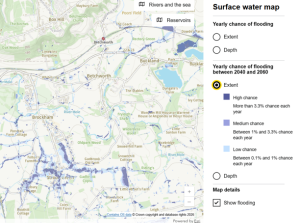
Surface water map
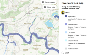
River map
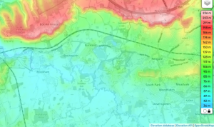
Elevation levels
Betchworth Strengths
- Betchworth has a strong community.
- We have an existing 4Bs Biodiversity Initiative in progress under the reBetchworth Nature Group.
- Community bonds with neighbouring villages are strong meaning we are joined up, cohesive, and sharing information.
- The Parish Council can review planning applications.
Natural Betchworth Assets
- Betchworth Estate – agricultural farmland
- Tranquil Wood ancient woodland
- North Downs School playing field
- Burial Ground and Church Cemetery
- Goulborn Green park and playground
- On the Pilgrim’s way footpath
- Proposed AONB
- Conservation area
- Nature B-line and Biodiversity Opportunity Area
- 4Bs Biodiversity Initiative
- Chalkdown and bat SSSI, Special Area of Conservation (Betchworth Quarry falls within the Mole Gap to Reigate Escarpment SAC)
- Lime chimneys (Bat Colony Sanctuary)
- Dedicated hedgehog corridors
- Parish wildflower sanctuaries
- River Mole Catchment Area and River Mole passes through the village
- Underground aquifer below the chalk in the lower greensand
Emissions Sources
- Betchworth is a rural parish situated within the Mole Valley District Council area, its carbon emissions are largely driven by domestic heating and road transport. (source https://impact-tool.org.uk)
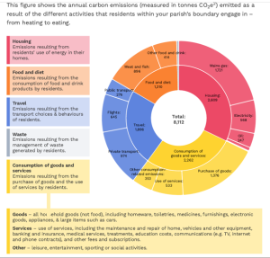
Carbon Emissions
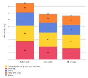
Carbon Sources
- Heating – Betchworth has an old housing stock reliant on gas with poor insulation.
- Travel – Betchworth Station remains one of the quietest railway stations in Surrey and leaves residents heavily reliant on vehicles. The Bus service is standard for Mole Valley, however given the distributed nature of our village, the Bus service is not walkable distance from many houses (I note the Surrey Connect Bus is trying to address this). Gatwick Airport is expected to increase visitors by 25 million in 10 years which will increase traffic going through the village (and over Betchworth Bridge).
- Consumption of goods/services – Compared to the rest of the Mole Valley district, Betchworth has a high average household income and local rural logistics of transporting goods is high as larger shops are not within walking distance of residents.
- Food and diet – Wealthier rural demographics, like those in Betchworth, statistically purchase a higher proportion of fresh red meat, high-end cheeses, luxury products and air-freighted products per household compared to more urban, economically diverse areas. These food categories carry heavy methane and land-use footprints.
- Waste – Betchworth is a highly affluent village with high purchasing power, and therefore households naturally generate a higher volume of material waste per capita.
Articles
- What is climate change? A really simple guide – BBC News
- Heatwaves are going to be hotter and more frequent. We need to adapt to this new normal. Why are our heatwaves getting hotter? – BBC News
- As the Atlantic ocean looses its saltiness, we could see colder winters. After record heat, could the Atlantic make Britain’s weather even more extreme? – BBC News
- How climate change worsens heatwaves, droughts, fires and floods – BBC News
- As we approach 1.5C global temperature increase, weather extremes will worsen and we need to adapt. August joint hottest month on record as climate change and El Niño drive heat – BBC News
- Global warming can change clouds. As oceans warm, low cloud reduces, more sunlight warms the sea. The clues that hint our planet might be heating faster than we realised – BBC News
- Air pollution increases in heat waves How hot weather can make air pollution worse – BBC News
- Airports will get noisier due to climate change say scientists – BBC News
- UK autumn forecast: El Niño to cause wetter and warmer-than-normal season – BBC Weather
- Some of the village would qualify for a free survey if you are in the conservation area with low energy rated homes. https://circulardorking.org.uk/projects/free-energy-surveys-are-back-through-our-home-energy-advice-taskforce-heat/
- Current groundwater levels https://www.seswater.co.uk/your-environment/water-resources/rainfall-and-resources